

Rencon Air and Land is thrilled to share the news: we’ve just acquired the brand‑new DJI Matrice 400 (M400.)
The M400 made its official debut worldwide on 10 June 2025, and in Australia it became available almost immediately after—helping bring the most advanced commercial drone capabilities to local operators.
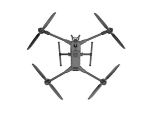
Source: DJI
What Makes the M400 Special?
First off, because this is such a remarkable piece of technology, here are some fun facts to kick things off.
- The DJI Matrice 400 can lift an impressive 6 kg of payload—enough to carry multiple cameras, sensors, spotlights, even embedded computing units.
- It can fly for up to 59 minutes on a single battery—even when hauling gear—making it truly test the boundaries of what drone endurance can be.
- It’s decked out with a 360° rotating LiDAR, full-colour surround vision cameras, and six-direction mmWave radar, giving it some of the most advanced obstacle detection ever seen in a commercial drone.
- That LiDAR alone pumps out half a million points per second, enough to detect thin power lines at distances up to 35 metres.
- It pushes video and control signals up to 40 km under unobstructed conditions via the O4 Enhanced Video Transmission System.
How We’ll Put the M400 to Work
Imagine combining aerial vantage with precise data-gathering—this drone is built for it. Here’s how Rencon Air and Land plans to harness its power.
When we survey large property parcels, the M400’s extended endurance allows us to cover more ground in a single flight. Whether you are assessing land boundaries or planning new infrastructure, we will capture high-resolution imagery and 3D terrain data more efficiently than ever.
In detailed inspections—like remote sites in QLD & NSW —the M400’s multi-sensor capabilities stand out. We can attach a visual camera, a thermal sensor, and a LiDAR scanner simultaneously. This means thermal hotspots, irregularites, and surface deformations are all documented in one sweep.
Mapping is not limited to land alone. The drone’s IP55 rating means it is built to handle adverse weather. Reliable in dusty, damp, or even light-rain conditions, the M400 lets us keep data collection rolling even when the elements are not cooperative.
For emergency response or urgent site assessments—like storm damage or flood impact—the drone gives us unmatched capability. Long range, quick deployment, and intelligence: that’s what makes it so valuable in time‑sensitive situations.
The Data and Technology That Drive It
On the tech side, the M400 is nothing short of a marvel.
The obstacle sensing system combines rotating LiDAR for full horizontal awareness, mmWave radar for penetrating fog or dust, and full‑colour fisheye vision cams that improve visual navigation—even in difficult lighting.
A single high-capacity battery system (TB100C) streamlines operations and lasts through many charging cycles. For long-term operations, there is even tethered power support for continuous flight.
Connectivity is strong: the O4 system supports long-range and relay-based video transmission, while software like DJI Pilot 2, DJI Terra, and FlightHub 2 make automating flights, mapping terrains, and monitoring missions more intuitive.
Bringing New Capability to Your Land
We are eager to introduce the M400 into our toolkit because it redefines what Rencon Air and Land can offer. From surveying large estates and infrastructure, to conducting efficient, multi-sensor inspections, to delivering rapid response aerial data, this drone expands our service horizon dramatically.
We look forward to bringing this powerful capability to your property—whether it’s for mapping, inspection, monitoring, or innovative agri-tech applications. The M400 raises the bar for what you can expect from aerial data solutions.
We cannot wait to show you what is possible with the DJI Matrice 400. Take your projects to new heights.
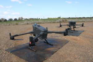
Our new M400 pictured in the foreground, sitting next to its older sibling the M350.
Thanks for trusting Rencon Air and Land—where high tech meets practical and trusted services. Contact us today for more information.