
")
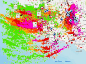
When the Bureau of Meteorology (BoM) reported that 25,000 to 46,000 lightning strikes hit the region in a single day, it was a stark reminder of how powerful and unpredictable nature can be. This extreme weather event, which occurred on March 9th and 10th, brought widespread lightning storms that had significant implications for landowners, firefighters, and emergency response teams.
How Does the Bureau of Meteorology Track Lightning Strikes?
The BoM uses advanced lightning detection networks that track electrical discharges in real-time. These systems measure the electromagnetic pulses generated by lightning and calculate the number, location, and intensity of strikes. This data helps predict potential fire risks and allows emergency services to prepare for immediate response efforts.

The Storm in Casterton: A Timeline
The storm hit Casterton in the evening and raged on for nearly 12 hours through the night. With three intense bands of lightning, reports varied from 25,000 to 46,000 strikes across the region. Fire risk was immediate, but due to overnight rainfall and lingering drizzle, some areas remained damp through Monday morning. However, minimal rain fell across large parts of the estate, meaning that as the week heated up, multiple fires ignited throughout the region, particularly in local, state, and national parks.
Firefighters, including Rencon Air & Land crews, monitored impact zones, watching for smoke sightings that could indicate emerging fires. It was an exceptionally busy time for emergency responders. One officer described the experience: “I was on call to fight fires that long weekend and then transitioned from ABP Field Officer straight into ABP Duty Officer on the Monday evening. Probably the hardest Duty Officer week I have ever undertaken.”
The Fire Response: Waiting and Reacting
Fire crews had little choice but to wait in fire towers and offices until daylight, when they could assess the full impact of the storm. As Monday progressed and conditions dried up, reports of smoke sightings began to roll in. The Rencon team, along with CFA and FIB resources, sprang into action, tackling multiple fires ignited by the lightning.
When the Ground Dried, the Fires Took Hold
By Tuesday, conditions had shifted dramatically. The damp ground dried out, and several lightning-induced fires flared up. The Rencon crews managed two significant fires in the Casterton area with a well-prepared team consisting of six personnel on the ground in Casterton and another six in Hamilton. With a rapidly changing fire landscape and escalating demands, the response effort required relentless coordination, patience, and adaptability.
A Collaborative Effort
In the face of extreme weather, teamwork is everything. Fire crews, landowners, and emergency services all played a role in responding to this event. With so many fires sparked across the region, emergency services were stretched to their limits, making local response teams and private fire crews, such as those at Rencon Air & Land, essential to containing the blazes.
Thanks to the dedication of those on the ground, including Rencon Air & Land’s committed workforce, the impact of this unprecedented lightning event was managed effectively. As we head into future storm seasons, staying informed and prepared remains the best defense against nature’s unpredictable power.